About West Coast U.S.A. Tide Tables
NO SPAM ADS. Voted #1: Most accurate tide/weather app by SkiffLife.com for 3 years running. Simple to use, Satellite Map based tide charts of the entire West Coast tide tables on a simple to use satellite map. Designed by...
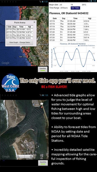
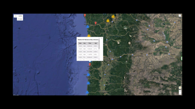
NO SPAM ADS. Voted #1: Most accurate tide/weather app by SkiffLife.com for 3 years running. Simple to use, Satellite Map based tide charts of the entire West Coast tide tables on a simple to use satellite map. Designed by fishermen and fishing guides. NO SPAM ADS, SIMPLE TO USE...100% AD FREE. This edition covers the following tide charts: California tides, Oregon tides, and Washington State tides. Oregon tides as well as California and Washington State including some rivers as far inland as NOAA has reporting tidal stations. Other Features: Easy to Use, advanced tide graphs allow for you to judge the level of water movement for optimal fishing between high and low tide. Ability to forecast tides from NOAA by setting date and period for any of the tidal stations for the entire West Coast of the U.S.: California tides, Oregon tides, and Washington State tides. When GPS is available we auto-locate your position and zoom to the map for surrounding NOAA tide stations near you. Included is the ability to zoom and view satellite imagery for fishing ground characteristics to compare with tide movement. Simply the easiest way to locate Oregon tide tables, California tide tables, and Washington State tide tables directly from NOAA. Points of interest include entire NOAA tides for: Oregon Tides, Washington Tides, California Tides Support URL: http://www.nestides.com/contact-us/ Privacy Policy & Terms of Use URL: http://www.progresstechnologies.com/blog/120/privacy-policy-and-terms-of-use/
Oct 26, 2017 Version 3.5 Updated satellite mapping view for closer zoom to likely fishing spots.
Previous Versions
Here you can find the changelog of West Coast U.S.A. Tide Tables since it was posted on our website on 2016-09-30 02:14:13.
The latest version is 3.5 and it was updated on 2024-04-23 08:50:39. See below the changes in each version.
West Coast U.S.A. Tide Tables version 3.5
Updated At: 2017-10-26
Changes: Oct 26, 2017 Version 3.5
Updated satellite mapping view for closer zoom to likely fishing spots.
West Coast U.S.A. Tide Tables version 3.5
Updated At: 2017-10-26
Changes: 26 Oct 2017 Version 3.5
Updated satellite mapping view for closer zoom to likely fishing spots.
West Coast U.S.A. Tide Tables version 3.4
Updated At: 2012-11-02
West Coast U.S.A. Tide Tables version 3.5
Updated At: 1970-01-01
Changes: 2017年10月26日 Version 3.5
Updated satellite mapping view for closer zoom to likely fishing spots.
West Coast U.S.A. Tide Tables version 3.5
Updated At: 1970-01-01
Changes: 26 Eki 2017 Version 3.5
Updated satellite mapping view for closer zoom to likely fishing spots.
Disclaimer
Official App Store Link
We do not host West Coast U.S.A. Tide Tables on our servers. We did not scan it for viruses, adware, spyware or other type of malware. This app is hosted by Apple and passed their terms and conditions to be listed there. We recommend caution when installing it.
The App Store link for West Coast U.S.A. Tide Tables is provided to you by apps112.com without any warranties, representations or guarantees of any kind, so access it at your own risk.
If you have questions regarding this particular app contact the publisher directly. For questions about the functionalities of apps112.com contact us.